By Horst Augustinovic
Following the accidental settlement of Bermuda on July 28th 1609 by the survivors of the ‘Sea Venture’, the island was at one point occupied by only two, and later three, men. It wasn’t until 1612 with the arrival of ‘The Plough’ from England, that Bermuda was deliberately colonized and a Governor – Richard Moore – established. In 1616 Captain Daniel Tucker, after spending five years in Virginia, became Governor of Bermuda.
An initial survey of Bermuda had began by Governor Moore, however, it was Governor Tucker who in 1616 called upon Richard Norwood to make a detailed survey and divide the island into eight Tribes, each sub-divided into fifty 25-acre plots. (The Bermuda Charter had specified that one quarter of the land was to be public land and this included St. George’s Island, St. David’s Island, Longbird Island, Smith’s Island, Cooper’s Island, Coney Island, Nonsuch Island, as well as a small portion at the eastern end of the Main Island).
Richard Norwood had quite a task, calculating the exact size of the proposed eight Tribes from the remaining land, especially when considering that the island was covered in dense cedar forests, that there were no roads and that 120 islands were included! Still, he came up with eight Tribes of exactly the same size – 2.0355 square miles – each of which was divided into fifty 25-acre plots.
Before sailing back to England with the data for his map in 1617, Richard Norwood became involved in what was known as the ‘overplus scandal’. Governor Tucker had been promised three shares of land by the Somers Island Company and Richard Norwood had made allowance for this ‘overplus’ in his calculations, however, as the survey was done from east to west, Governor Tucker’s ‘overplus’ would fall at the extreme west end of the island.
As Richard Norwood approached the western end of the main island (now Southampton), he informed the Governor that he had seen a beautiful valley of ‘fatte and lustye soyle’. Delighted by this news, Governor Tucker abruptly ordered Norwood to continue the survey from the very western end of the island (now Sandys). The official reason for this change in plans was the fact that the western islands had not yet been invaded by rats and it would therefore be easier for Norwood to conduct his survey. Conveniently Governor Tucker’s ‘overplus’ now fell exactly into the area he wanted for himself.
When he proceeded to build a large cedar house at public expense on his 200 acres of land, even the Somers Island Company in London was outraged and threatened to deprive him of his ‘overplus’ and the house he built at their expense. Fortunately he was able to send a huge consignment of tobacco to London which appeased the company and he was able to retain his now famous house, as well as almost half the property.
The eight Tribes were eventually called Parishes and the eastern islands where Bermuda’s development started, became the ninth Parish – St. George’s. So do you know about our nine parishes & who they are named after? In most cases they were Elizabethan aristocrats who considered themselves ‘Gentlemen Adventurers’ and who were the largest shareholders of their Tribe.
From East to West, St. George’s is named after the Patron Saint of England, however, as Sir George Somers was the founder of Bermuda, many consider that St. George’s is named after him. Hamilton Parish is named after James Hamilton, 2nd Marquess of Hamilton; Smith’s Parish after Sir Thomas Smith; Devonshire after William Cavendish, 1st Earl of Devonshire; Pembroke after William Herbert, 3rd Earl of Pembroke; Paget after William Paget, 4th Lord Paget; Warwick after Robert Rich, 2nd Earl of Warwick; Southampton after Henry Wriothesley, 3rd Earl of Southampton and Sandys after Sir Edwin Sandys.
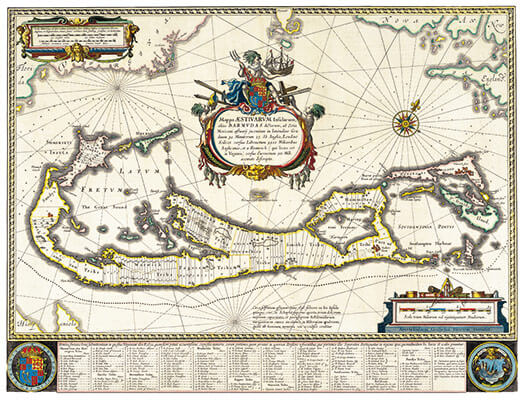
First featured image: Map of Bermuda engraved by Guijelm Blaeuw in 1630 shows the division of the island into eight Tribes and the subdivisions into 25-acre plots. If one person owned more that one plot, the total is shown as one plot and numbered accordingly.
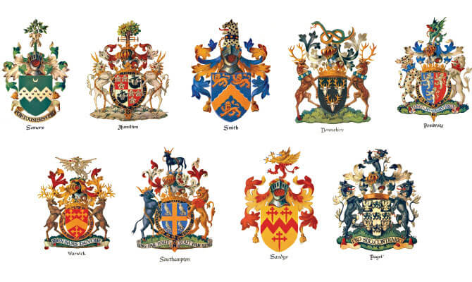
Second featured image: The family crests of each ‘Gentleman Adventurer’ shown here were painted by William Harrington on the occasion of Bermuda’s 350th Anniversary for display at the Bermuda Airport.
Comments: netlink@link.bm